


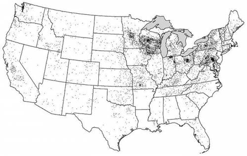
A. Identify ONE type of boundary data shown on the map.
B. Identify the region of the Un...

Geography, 09.04.2020 08:16, katherineweightman
A. Identify ONE type of boundary data shown on the map.
B. Identify the region of the United States where most dairy farms are located.
C. Identify ONE spatial pattern shown on the map.
D. Describe the characteristic land use associated with the spatial pattern shown on the map.
E. Describe TWO geographic features not shown on the map that would help explain the patterns of dairy farming shown on the map.

Answers: 1
Other questions on the subject: Geography
Geography, 22.06.2019 13:00, alexisdiaz365
While most people who lived in ancient egypt and the middle east avoided settling in nearby deserts, those regions protected them from their enemies. why do you think this was true?
Answers: 1
Geography, 22.06.2019 17:10, shelbybibb99
Most countries in the middle east must import a majority of their a. gasoline b. oil c. food d. water
Answers: 1
Geography, 22.06.2019 17:30, kayolaaaa53
The government of country a has determined there is a coal shortage a seed on mining reports as a result of these data the government decreases coal exports to other nations access to information country a
Answers: 1
Geography, 22.06.2019 21:30, htahir2345
In which area will soil formation be greatest? a a steep slope in a warm, b wet climate a flat area in a warm, c wet climate a north-facing area on a steep slope a flat area in a cold, d wet climate description
Answers: 2
Do you know the correct answer?
Questions in other subjects:


Mathematics, 07.10.2021 14:00
Biology, 07.10.2021 14:00


Physics, 07.10.2021 14:00

Computers and Technology, 07.10.2021 14:00
Biology, 07.10.2021 14:00


