

History, 12.08.2021 20:50, lacyfigueroa
Analyze the image below and answer the question that follows.
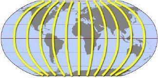
The imaginary lines highlighted on the map travel from north to south and are used to measure distance from the Prime Meridian. They are _.
A.
lines of latitude
B.
lines of longitude
C.
date lines
D.
time zone lines
Please select the best answer from the choices provided
A
B
C
D

Answers: 3


Other questions on the subject: History
History, 22.06.2019 00:20, avrieell8584
Why is julius caesar considered an important roman leader? a. his assassination led to a civil war that ended the roman republic. b. his commitment to justice led to the creation of the twelve tablesc. his support for democracy led to expand voting rights for all romansd. his policies as dictator led to a period of peace known as the pax romana
Answers: 1
History, 22.06.2019 06:00, jasonlawrencejr6844
Historians sometimes rely on video recordings in researching past events because
Answers: 2
Do you know the correct answer?
Analyze the image below and answer the question that follows.
The imaginary lines highlighted on th...
Questions in other subjects:

Mathematics, 18.10.2020 06:01
Mathematics, 18.10.2020 06:01


Arts, 18.10.2020 06:01
Mathematics, 18.10.2020 06:01
Mathematics, 18.10.2020 06:01


