

History, 21.01.2021 18:20, AbhiramAkella
Compare maps of the world in ancient times with current political maps. Use the maps below to answer the following question: First image. A map of North America showing the regions of Native American cultures. Second image. A political map of the United States, with all 50 states labeled. Washington, Oregon, and California are on the west coast. Moving east, from north to south, Montana, Idaho, Wyoming, Nevada, Utah, and Arizona are next seen. Then, North Dakota, South Dakota, Nebraska, Colorado, Kansas, Oklahoma, New Mexico, and Texas are seen, from north to south, in the central US. East of those states, from north to south, Minnesota, Iowa, Missouri, Arkansas, and Louisiana are seen. Wisconsin, Michigan, Illinois, Indiana, and Ohio in the Midwest, and Pennsylvania and New York in the northeast, border the Great Lakes. Kentucky, Tennessee, Mississippi, Alabama, Virginia, North Carolina, South Carolina, Georgia, and Florida are in the southeast, with Florida jutting out as a peninsula. Maryland, West Virginia, Delaware, and New Jersey are between the southeast and northeast states. Connecticut, Rhode Island, Massachusetts, New Hampshire, Vermont, and Maine are in the northeast. Alaska and Hawaii are seen as islands. Compare the two maps. Which state listed below was located in the Southeast Native American cultural region?
A. California
B. New York
C. Washington
D. Georgia

Answers: 3


Other questions on the subject: History
History, 21.06.2019 22:30, girlwholikesanime
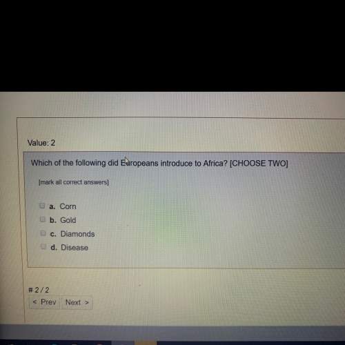
Which is not an abundant natural resource found in africa?
Answers: 1
History, 22.06.2019 04:00, Beast3dgar
What was v-e day? a. victory in england day b. victory in europe day c. victory in japan day d. victory every day
Answers: 2
Do you know the correct answer?
Compare maps of the world in ancient times with current political maps. Use the maps below to answer...
Questions in other subjects:


Advanced Placement (AP), 29.03.2021 23:20

Mathematics, 29.03.2021 23:20
Mathematics, 29.03.2021 23:20

Mathematics, 29.03.2021 23:20


