

History, 20.11.2020 20:10, ayshearouse1203
Compare maps of the world in ancient times with current political maps.
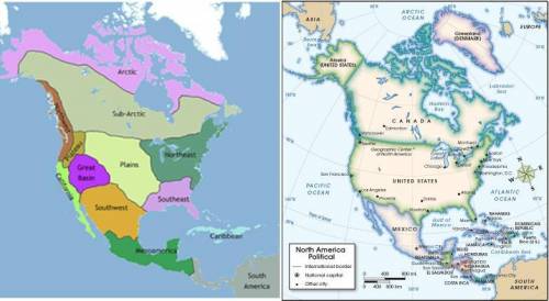
First image. Map of North America showing the regions in which Native American tribes lived in ancient times. The Arctic and sub-Arctic are at the top of the continent, respectively. On the west coast, California and the Northwest region are labeled. Slightly interior to the west coast are the Plateau region and the Great Basin. Beneath and east of the Great Basin is the Southwest, which borders the Plains to its East and Mesoamerica to the south. South America is labeled, to the southeast of Mesoamerica. The Plains takes up a large portion of central North America. The Northeast and Southeast also are labeled, east of the Plains and extending to the Atlantic coast. The Caribbean islands are seen off the Southeast coast. Second image. Political map of North and Central America. The United States appears in between Canada to the north and Mexico to the south. Alaska is seen as a peninsula off of western Canada. In the United States, the cities of Seattle on the northwest coast, San Francisco and Los Angeles on central and south west coast, respectively, Phoenix in the southwest, Dallas and Houston in the central south, Chicago in the central plains area, Atlanta in the southwest, and Boston, New York, Philadelphia, and Washington D. C. in the northeast are labeled.
© 2012 The Exploration Company
Compare the two maps. In which of the following modern-day cities did the Southwest tribes live in? (4 points)
a
San Francisco
b
Seattle
c
Boston
d
Phoenix

Answers: 3


Other questions on the subject: History
History, 22.06.2019 02:00, Bradgarner772
Which lake receives up to 9 million visitors each year, covers more than 90,000 acres, and was created by denison dam? a. the grand lake o' the cherokees b. lake thunderbird c. lake eufaula d. lake texoma
Answers: 2
History, 22.06.2019 03:00, edwardordonez66
The quote below is an excerpt from the charter of the united nations: "the purposes of the united nations are: to maintain international peace and security, and to that end: to take effective collective measures for the prevention and removal of threats to the peace, and for the suppression of acts of aggression or other breaches of the peace, and to bring about by peaceful means, and in conformity with the principles of justice and international law, adjustment or settlement of international disputes or situations which might lead to a breach of the peace . " source:this section implies that the united nations is prepared to do what to keep world peace?
Answers: 1
Do you know the correct answer?
Compare maps of the world in ancient times with current political maps.
First image. Map of North A...
Questions in other subjects:
History, 14.07.2019 01:30

Mathematics, 14.07.2019 01:30

Computers and Technology, 14.07.2019 01:30
Mathematics, 14.07.2019 01:30


Advanced Placement (AP), 14.07.2019 01:30


