

History, 10.11.2020 14:00, roblesjairus
Analyze the purposes of map projections (political, physical, special purpose) and explain the applications of various types of maps.
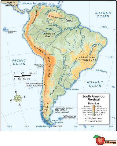
Use the map below to answer the following question:
Physical map of South America, with longitude and latitude lines spanning from 100 W longitude to 15 W longitude, and 45 S latitude to 15 N latitude. Orange coloration shows Andes Mountains to the west, and Brazilian Highlands to the east, as well as Guiana Highlands to the north. Amazon River Basin is shown, as well as clear views of the Pacific and Atlantic Oceans to the west and east, respectively.
© 2012 The Exploration Company
What question would this map be most likely to answer about the Incan civilization?
Which highlands did the Incans' enemies come from?
How many people lived at the lowest elevation point?
What physical characteristics existed in Incan territory?
How did the major rivers affect trade with the Incans?

Answers: 3


Other questions on the subject: History
History, 21.06.2019 22:00, birdman9416
Averb diagram that shows the similarities and differences of two african kingdoms
Answers: 1
History, 22.06.2019 00:30, juliannabartra
Does anyone know the song that xxxtentacion sings and when he says "hey is your neck game sloppy' i need to know what son that is hurry
Answers: 2
History, 22.06.2019 05:30, LuckyCharms988
Europe and asia are divided by a. the alps c. the pyrennes b. the northern european plain d. the ural mountains select the best answer from the choices provided a b c d
Answers: 1
Do you know the correct answer?
Analyze the purposes of map projections (political, physical, special purpose) and explain the appli...
Questions in other subjects:


Mathematics, 19.02.2021 02:00


