

Compare maps of the world in ancient times with current political maps.
Use the maps below to answer the following question.
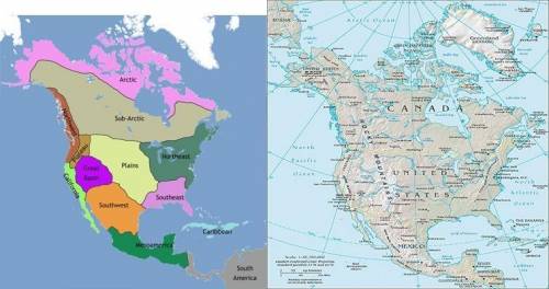
Image of two maps side by side. The map on the left shows a map of North America showing different cultural regions. In the south there is Mesoamerica. Above Mesoamerica is the Southwest. Along the Pacific Coast is the Pacific Northwest. Beside the Pacific Northwest and in the center of what is now the United States there is the Great Plains, Great Basin, and Plateau. On the eastern side of the continent is the Eastern Woodlands. In the North, there is the Subarctic and the Arctic. The map on the right shows a map of the United States showing all states.
Based on these maps, which state listed below was located in the Northeast Native American cultural region?
Texas
Colorado
New York
California

Answers: 1


Other questions on the subject: History
History, 21.06.2019 16:30, loxtin495
Which of the following best describes the state of the us economy at the end of world war ii? a it was starting to come out of the great depression. b it was out of the great depression and doing better. c it was one of the most powerful economies in the world. d it was entering another recession.
Answers: 1
History, 21.06.2019 16:40, eelebron0905
When an imperial power has political control, what is the territorial called
Answers: 2
Do you know the correct answer?
Compare maps of the world in ancient times with current political maps.
Use the maps below to answe...
Questions in other subjects:

Mathematics, 20.09.2020 03:01


Mathematics, 20.09.2020 03:01

Health, 20.09.2020 03:01
History, 20.09.2020 03:01
History, 20.09.2020 03:01
Mathematics, 20.09.2020 03:01
Mathematics, 20.09.2020 03:01


