

History, 02.10.2020 14:01, bossefamily1
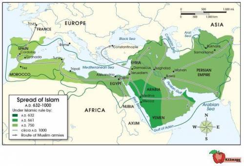
The following map shows the spread of Islam from 632 A. D. (CE) to 1000 A. D. (CE). Use the map to answer the following question:
A map showing the spread of Islam from 632 A. D. (CE) to 1000 A. D. (CE). The spread of Islam during this period extended to include the northern coast of Africa, Morocco, Egypt, the Arabian Peninsula, the Persian Empire, Syria, and Spain. Large bodies of water shown on the map include the Mediterranean Sea (bordering northern Africa), the Red Seas (bordering the eastern coast of the Arabian Peninsula), the gulf of Aden (bordering the southern coast of the Arabian Peninsula), the Arabian Sea (bordering the southeastern coast of the Arabian Peninsula), Caspian Sea (north of the Persian Empire), and the Black Sea (north of Syria).
© 2012 The Exploration Company
What does this map indicate about the Crusades?
The Crusades were a direct result of Muslim conquest of Jerusalem.
Much of the Holy Land had been under Muslim control for centuries before the Crusades began.
The Crusades were a direct result of Muslim invasion of Tours.
Land bordering the Mediterranean Sea was not a concern for Crusaders.

Answers: 2


Other questions on the subject: History
History, 22.06.2019 05:00, nekathadon
Use the image to answer the question, rid egypt what do the structures in this photograph suggest about ancient egypt?
Answers: 3
History, 22.06.2019 06:00, Bg88860709
How do you think sintonis fiancée reacted to receiving this letter?
Answers: 1
History, 22.06.2019 06:10, jacquetpaul1969
Match each mode of narration to the excerpt in which it is used
Answers: 3
Do you know the correct answer?
The following map shows the spread of Islam from 632 A. D. (CE) to 1000 A. D. (CE). Use the map to a...
Questions in other subjects:


Mathematics, 15.10.2019 18:50
Mathematics, 15.10.2019 18:50

English, 15.10.2019 18:50
Health, 15.10.2019 18:50


Business, 15.10.2019 18:50


