

Geography, 08.02.2022 14:00, bernadetteindre6650
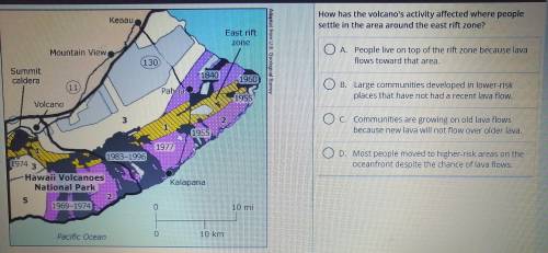
The map shows the hazard zones for lava flows from the Kilauea volcano. Dark areas with dates show the paths of major lava flows. Areas with a range of dates had multiple flows. The risk of a lava flow ranges from high risk (1) to much lower risk (5). Light Grey areas show where people live, and circled numbers indicates the number of houses in the area.

Answers: 3


Other questions on the subject: Geography
Geography, 22.06.2019 12:30, isabelsmhl
Write a short paragraph of about 150-300 words. explain how the physical environment can limit human activities.
Answers: 1
Do you know the correct answer?
The map shows the hazard zones for lava flows from the Kilauea volcano. Dark areas with dates show t...
Questions in other subjects:


Biology, 31.07.2019 22:30


