


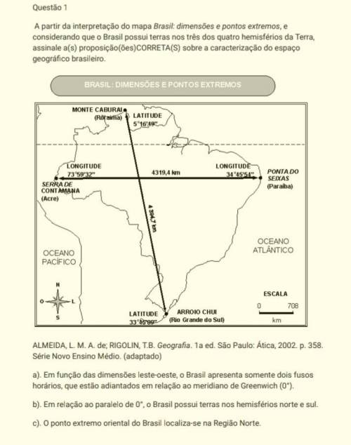
Questão 1
A partir da interpretação do mapa Brasil: dimensões e pontos extremos, e
consideran...

Geography, 01.04.2021 22:20, cierra3678
Questão 1
A partir da interpretação do mapa Brasil: dimensões e pontos extremos, e
considerando que o Brasil possui terras nos três dos quatro hemisférios da Terra,
assinale a(s) proposição(ões)CORRETA(S) sobre a caracterização do espaço
geográfico brasileiro.
ALMEIDA, L. M. A. de; RIGOLIN, T. B. Geografia. 1a ed. São Paulo: Ática, 2002. p. 358.
Série Novo Ensino Médio. (adaptado)
a). Em função das dimensões leste-oeste, o Brasil apresenta somente dois fusos
horários, que estão adiantados em relação ao meridiano de Greenwich (0°).
b). Em relação ao paralelo de 0°, o Brasil possui terras nos hemisférios norte e sul.
c). O ponto extremo oriental do Brasil localiza-se na Região Norte.
AJUDA?

Answers: 2
Other questions on the subject: Geography
Geography, 22.06.2019 08:30, culturedxnat
Which of the following countries has declared itself nuclear free
Answers: 1
Geography, 23.06.2019 05:00, khamyah96
1. crust 1 the metallic layer at the earth's center 2. inner core 3 the firm layer between the crust and the asthenosphere 3. lower mantle 2 the layer surrounding the inner core 4. asthenosphere 4 the semi-solid layer between the top layer and the upper mantle 5. upper mantle 5 the layer between the asthenosphere and lower mantle 6. top layer 6 the earth's outermost layer 7. outer core 7 the hottest part of the mantle
Answers: 1
Do you know the correct answer?
Questions in other subjects:


Geography, 21.10.2019 18:30


