

Geography, 24.02.2021 19:50, jasmine2531
Analyze the map below and answer the question that follows.
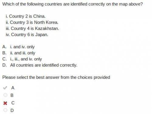
A political map of Asia. Countries are labeled 1 to 7. 1 is between Russia and Uzbekistan. 2 is one of the largest countries in Asia between Mongolia and India. 3 is between China and Russia. 4 and 5 is a peninsula off the northern coast of China between China and Japan. 6 is a large island east of China and Korea. 7 is between Pakistan and Bangladesh.
Image by historicair
Which of the countries on the map above is North Korea?
A.
number 1
B.
number 2
C.
number 3
D.
number 4

Answers: 2


Other questions on the subject: Geography
Geography, 22.06.2019 07:20, Vugly
Which of the following statements is true? a. there is not enough food produced in the world to feed everyone. b. the biggest cause of hunger and malnutrition is the cost of getting food to people who need it most. c. most countries have enough arable land and resources to feed their own population and export a surplus d. malnourishment is only seen in a few countries with very limited food supplies.
Answers: 2
Do you know the correct answer?
Analyze the map below and answer the question that follows.
A political map of Asia. Countries are...
Questions in other subjects:

Social Studies, 10.10.2019 02:00


Mathematics, 10.10.2019 02:00
Mathematics, 10.10.2019 02:00
Mathematics, 10.10.2019 02:00

History, 10.10.2019 02:00
English, 10.10.2019 02:00


