

Examine the map of North American physical regions.
A map of North American geographic physical regions. A key notes color-coded regions. The Coastal Range is from the coast of Alaska to Oregon, California, and Mexico. The Basin and Range is from Alaska to Mexico through Nevada and Arizona. The Rocky Mountains are from Alaska to Wyoming. The Great Plains are from Canada to Texas. The Interior Lowlands are from Northern Canada to Texas and most of the Midwest. The Canadian Shield is majority of Canada and it's islands. The Appalachian Mountains are from Alabama and Georgia to Maine and Canada. The Coastal Plains are from the coast of Mexico, Louisiana, Mississippi, and Florida, and along the East Coast.
Which physical region is found in all three countries of North America?
Great Plains
Interior Lowlands
Basin and Range
Appalachian Mountains
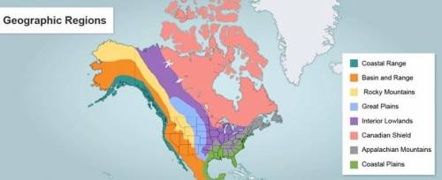

Answers: 1


Other questions on the subject: Geography
Geography, 21.06.2019 14:30, lindselu
Which statement about glaciers is true? a. glaciers can only be found high up in mountains. b. glaciers have snow all year round, except during july. c. there are two types of glaciers: alpine and continental. d. glaciers can only be found near earth's north and south poles.
Answers: 1
Geography, 22.06.2019 22:40, annie1799
[fw.02]diana is studying four surface features of florida. she classifies the surface features and places them in different columns of a chart as shown below. surface features column 1 column 2 hot springs sinkholes caverns geysers which of these titles best represents column 1 of diana's chart? formed by freezing groundwater o formed by heating groundwater o formed by evaporation of groundwater o formed by chemical action of groundwater
Answers: 2
Do you know the correct answer?
Examine the map of North American physical regions.
A map of North American geographic physical reg...
Questions in other subjects:

Mathematics, 26.06.2019 16:30
Mathematics, 26.06.2019 16:30

English, 26.06.2019 16:30


Mathematics, 26.06.2019 16:30
Mathematics, 26.06.2019 16:30


