

Geography, 11.11.2020 21:20, erenackermanlevijaeg
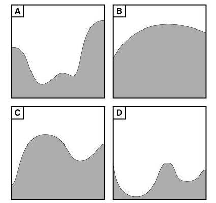
Part 2 What is the contour interval? In what direction is Maklaks Spring flowing (downstream)? How can you tell? Which area is most steep of the areas enclosed in red, blue, green, or orange circles? How can you tell? If you were standing on the east side of the feature that has its highest point of elevation at 6,168 (shown in the yellow square box), what graphic would most represent the shape or profile of the geographical feature? Provide an approximate elevation for points W, X, Y, and Z (Z is pointing right to the line).

Answers: 2


Other questions on the subject: Geography
Geography, 23.06.2019 00:20, leapfroggiez
If scientists only detect p waves in a certain layer of earths interior what does that tell us?
Answers: 1
Geography, 23.06.2019 05:50, cocomorillo35181
Which are evidence of the seafloor spreading? a. molten material b. magnetic stripes c. continental material d. drilled core samples e. ocean water samples
Answers: 2
Geography, 23.06.2019 16:30, bakaoffire
The rwandan patriotic front and the interahamwe were a. relief agencies b. military groups c. political parties d. nonprofit organizations select the best answer from the choices provided. a b c d
Answers: 1
Do you know the correct answer?
Part 2 What is the contour interval? In what direction is Maklaks Spring flowing (downstream)? How c...
Questions in other subjects:


Social Studies, 21.02.2022 02:10

Chemistry, 21.02.2022 02:10


Mathematics, 21.02.2022 02:10


