

Geography, 05.09.2020 01:01, maehardy4134
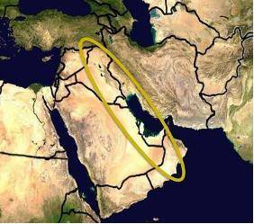
Analyze the map below and answer the question that follows. A satellite map of the Middle East. The west coast of the Arabian peninsula and western Iraq is circled. Image courtesy of NASA Which major economic activity in the Middle East occurs largely in the area circled on the map above? A. diamond mining B. farming C. nomadic herding D. oil production Please select the best answer from the choices provided A B C D Analyze the map below and answer the question that follows. A satellite map of the Middle East. The west coast of the Arabian peninsula and western Iraq is circled. Image courtesy of NASA Which major economic activity in the Middle East occurs largely in the area circled on the map above? A. diamond mining B. farming C. nomadic herding D. oil production Please select the best answer from the choices provided A B C D 25 points!

Answers: 1


Other questions on the subject: Geography
Geography, 23.06.2019 17:30, supermansabeast
Sink holes may eventually for to join a. wide valleys b. zone of aeration c. dripstones d. aquifer
Answers: 2
Geography, 23.06.2019 20:00, brownboimexican
Scientist: cross-sections of stalactites—calcite formations deposited on cave ceilings by seeping water—can reveal annual variations in rainfall in particular areas over hundreds and thousands of years. we often found that when—according to these cross-sections—drought occurred in a particular area, it coincided with the collapse of an ancient society in that area. i hypothesize that drought reduced agricultural productivity in these areas, thereby leaving these societies without the resources needed to handle internal stresses and external threats. which of the following, if true, would most weaken the support for the scientist's hypothesis? a. many droughts indicated in the cross-sections of stalactites do not correspond with the collapse of a society in that area. b. information from the cross-sections of stalactites alone cannot reveal the level of agricultural output in an area at a particular time. c. most of the societies that collapsed during droughts did so when internal power struggles coincided with military raids from neighboring societies. d. most of the societies that collapsed during droughts maintained large stockpiles of food and water at the time of their collapse. e. information from stalactites also suggests that the collapse of some societies coincided with periods of abnormally high rainfall.
Answers: 1
Geography, 24.06.2019 03:00, serenityjohnson98765
How far is a geographic second? a.) around 100 feet b.) around 1,000 feet c.) around 5,000 feet d.) none of the above
Answers: 2
Do you know the correct answer?
Analyze the map below and answer the question that follows. A satellite map of the Middle East. The...
Questions in other subjects:

Geography, 27.04.2021 06:30

Mathematics, 27.04.2021 06:30


History, 27.04.2021 06:30
Mathematics, 27.04.2021 06:30
Mathematics, 27.04.2021 06:30


