

Geography, 06.05.2020 09:04, eggyhz1980
The map below shows four major time zones of the United States. The dashed lines represent meridians of longitude. The locations of New York City and Denver are seen. What is the time in New York City when it is noon in Denver?
A) 10:00 a. m. C) 3 p. m.
B) 2 p. m. D) noon
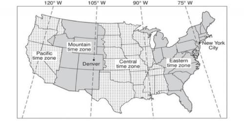

Answers: 3


Other questions on the subject: Geography
Geography, 21.06.2019 22:30, JewelzSkullz
Use a graphing calculator to solve the equation - 3 cos t = 1 in the interval from 0 ≤ theta ≤ 2 π round to the nearest hundredth.
Answers: 1
Geography, 22.06.2019 10:00, LilFreaky666
The diagram shows the positions of the sun, moon and earth during spring tides, when the high tides are at their highest and low tides at their lowest. what is it about these positions that causes these high and low tides?
Answers: 2
Do you know the correct answer?
The map below shows four major time zones of the United States. The dashed lines represent meridians...
Questions in other subjects:

Mathematics, 29.03.2021 20:30
Mathematics, 29.03.2021 20:30
Mathematics, 29.03.2021 20:30


Health, 29.03.2021 20:30
Mathematics, 29.03.2021 20:30
Mathematics, 29.03.2021 20:30


