

Geography, 22.04.2020 02:27, suselygonza
Compare the two maps shown, then answer the following questions. Which of the following is a characteristic of the Mercator projection?
The size and shape of countries in the higher latitudes are greatly exaggerated.
The size of all countries is accurate, but the shape is distorted.
Countries near the Equator appear 50 percent larger than countries in the middle latitudes.
The projection is designed to maintain undistorted outlines of landmasses.
Distances on the Mercator projection are real and accurate.
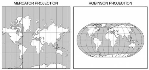

Answers: 3


Other questions on the subject: Geography
Geography, 22.06.2019 13:40, noglapotato
:calculate the sum of the interior angles of a 13-sided polygon.
Answers: 2
Geography, 22.06.2019 14:30, krisbarnett5353
The model of human settlement suggests that uthe model of human settlement suggests that urban growth is patterned around transportation networks such as railroads and highways. a. burgess b. hoyt c. sauer d. von thunenrban growth is patterned around transportation networks
Answers: 1
Geography, 22.06.2019 21:00, blessing03
When you cross a time zone going east what happens to the time
Answers: 1
Do you know the correct answer?
Compare the two maps shown, then answer the following questions. Which of the following is a charact...
Questions in other subjects:


Biology, 09.07.2019 17:40


History, 09.07.2019 17:40


