


1. the latitude is always given first, and the distance north and south of the imaginary line.
...

Geography, 25.09.2019 02:00, josephjannace12
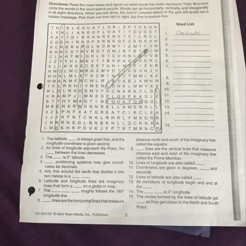
1. the latitude is always given first, and the distance north and south of the imaginary line.
longitude coordinate is given second,
called the equator
2. as lines of longitude approach the poles, the 9. lines are the vertical lines that measure
between the lines decreases.
distance east and west of the imaginary line
3. the i s 0° latitude.
called the prime meridian.
4. positioning systems may give coordi- 10. lines of longitude are also called
nates as decimals.
11. coordinates are given in degrees , and
5. any line around the earth that divides it into seconds.
two halves is a
12. lines of latitude are also called
6. latitude and longitude lines are imaginary 13. all meridians of longitude begin and end at
lines that form a o n a globe or map.
the
7. the
- roughly follows the 180° 14. the
is 0° longitude.
longitude line.
15. the circles formed by the lines of latitude get
8. lines are the horizontal lines that measure
as they get closer to the north and south
poles.

Answers: 2
Other questions on the subject: Geography
Geography, 23.06.2019 19:00, mimiloveyuhh
Which characteristics of temperature and salinity have the greatest influence on the movement of deep-ocean currentsa. warm and low salinityb. cold and high salinityc. cold and low salinityd. warm and high salinity
Answers: 1
Geography, 24.06.2019 07:00, GGerardi7552
Which features do all new rocks formed near an oceanic ridge share? check all that apply. pillow-shaped striped pattern provide evidence to seafloor spreading made from molten material iron oriented in same direction
Answers: 1
Do you know the correct answer?
Questions in other subjects:


