

Geography, 23.06.2019 19:30, markleal57151
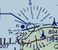
This is a 2017 topographic map of puerto rico in the united states, and i'm sorry that people there have suffered such a disaster. i want to ask, what do the yellow dots and areas represent on this graph? and the blue area and the little blue circle, and the little blue sign that looks like a signal tower, what do they stand for?

Answers: 2


Other questions on the subject: Geography
Geography, 23.06.2019 08:10, duxks
Which of the following best describes the purpose of a nation’s boundaries? a. to limit the movement of goods and people b. to make it easier for cartographers to create maps c. to make the movement of goods and people easier d. to prevent other countries from invading territory
Answers: 1
Geography, 23.06.2019 13:30, china1283
When volcanoes erupt, magma (hot, molten rock) rises toward the surface of the earth. as magma cools, solid rock forms. this rock contains substances from the interior of the earth. which of the following natural resources is likely to be plentiful near subduction zones where volcanic activity has occurred in the past?
Answers: 1
Do you know the correct answer?
This is a 2017 topographic map of puerto rico in the united states, and i'm sorry that people there...
Questions in other subjects:


Chemistry, 07.10.2019 10:50
Geography, 07.10.2019 10:50

Mathematics, 07.10.2019 10:50
History, 07.10.2019 10:50

Mathematics, 07.10.2019 10:50


